Pioneering work in establishing that the speed of the wind increased with elevation was initiated in the first world war by people like Robert Millikan who worked for the US signal corps. He wrote
Within the past year approximately 5000 . . . [pilot balloon] observations have been taken by the Meteorological Service of the Signal Corps . . . the balloon is kept in sight up to distances as great as 60 miles and up to heights as great as 32,000 meters, or approximately 20 miles . . . observations show air currents increasing in intensity with increasing altitude and approaching the huge speed of 100 miles per hour. Such speeds are perhaps exceptional but not at all uncommon.
Gordon Dobson followed up this work in the 1920’s.
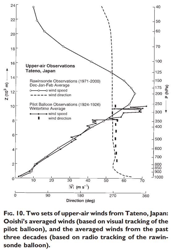
Wasaburo Ooishi in Japan amassed a total of 1288 observations between March 1923 and February 1925 and published a paper on the subject in Esperanto, to make it accessible to non-Japanese speakers.Here is Ooshi’s plot of wind speed as it varies with elevation in the vicinity of his observatory at Tateno, twenty kilometres north of Tokyo.
The seasonal variation in the winds was analysed.

Source: http://journals.ametsoc.org/doi/pdf/10.1175/BAMS-84-3-357
So, what drives the air so that its velocity increases with altitude? Why is the velocity greater in winter? Is it all driven by warming at the surface? Is it driven by the release of latent heat of condensation. Or is it differences in air density that manifest above the cloud layer in that confusing space that is shared by the troposphere and the stratosphere?
When surface pressure is high, there is little ozone in the upper air, the troposphere is 2-3 km higher. When surface pressure is lower there is more ozone in the upper air and the tropopause is lower. In high latitudes we have the side by side conjunction of these two species of air at The Polar Front. The classical illustration is in the southern hemisphere where a chain of low pressure cells sometimes described as the Circumpolar Trough constitutes the mixing zone for these different species of air with high surface pressure, ozone deficient air over the continent and low surface pressure, ozone rich air on the equatorial side of the trough.
This conjunction is an untenable situation. The stratospheric resolution of this unstable conjunction of two species of air is the polar vortex, a stream of ozone rich air circulating roughly about a particular line of latitude taking air to the top of the atmosphere. At 250 hPa this stream of high velocity air manifests as the jet stream. As the stream ascends further into the stratosphere its velocity increases. This is a winter phenomenon due to the descent of cold mesospheric air inside the stratospheric vortex at that time of the year.
The above is my view on the matter. Now lets look at the conventional meteorological viewpoint.
The explanation of the nature of the jet streams that appears below was, until recently, provided by the American Meteorological Society at: http://www.ametsoc.org/amsedu/proj_atm/modules/JetStreams.pdf
It is no longer available at that address.
In providing this paper I could not resist highlighting important statements in red, interspersing a few comments in blue (where the explanation can be improved) and I follow up with some comments at the end.
Introduction: Jet Streams
As World War II was approaching its conclusion, the United States introduced the first high-altitude bomber plane called the B-29. It could fly at altitudes well above 20,000 feet (6.1 kilometers). When the B-29s were being put into service from a Pacific island base, two air force meteorologists were assigned the task of producing a wind forecast for aircraft operations at such altitudes.
To make their prediction, the meteorologists used primarily surface observations and what is known in meteorology as the “thermal wind” relationship. In plain language, this relationship implies “that if you stand with your back to the wind, and the air is colder to the left and warmer to the right, the wind will get stronger on your back as you ascend in the atmosphere.” Using this relationship, the meteorologists then predicted a 168- knot wind from the west. Their commanding officer could not believe the estimate. However, on the next day, the B-29 pilots reported wind speeds of 170 knots from the west! The jet stream was discovered.
Actually atmospheric scientists had theorized the existence of jet streams at least as early as 1937. The bomber pilots just confirmed it. Now many television weathercasts mention the positions of jet streams and their impact on daily weather events.
Jet streams are relatively strong winds concentrated as narrow currents in the upper atmosphere. The polar-front jet stream is of special interest to meteorologists because of its association with the regions where warm and cold air masses come in contact and middle latitude storm systems evolve. The polar-front jet stream encircles the globe at altitudes between 6 and 8 miles (9 and 13 kilometers) above sea level in segments thousands of kilometers long, hundreds of kilometers wide, and several kilometers thick. It flows generally from west to east in great curving arcs. It is strongest in winter when core wind speeds are sometimes as high as 250 miles (400 kilometers) per hour.
Meteorologists study the polar-front jet stream as they forecast weather. Changes in it indicate changes in weather. The jet stream is also of importance to aviation, as the B- 29 pilots quickly found out. Westbound high-altitude flight routes are planned to avoid the jet-stream head winds. Eastbound flights welcome the time-saving tail winds. However, the jet stream produces strong wind shears in some locations because of large changes in wind speeds over short vertical and horizontal distances. The resulting air turbulence can be very hazardous to aircraft.
The polar-front jet stream’s location is one of the most influential factors on the daily weather pattern across the United States.
Characteristics of the Polar-Front Jet Stream
- Jet streams are relatively high speed west-to-east winds concentrated as narrow currents at altitudes of 6 to 9 miles (9 to 14 kilometers) above sea level. These meandering “rivers” of air can be traced around the globe in segments thousands of kilometers long, hundreds of kilometers wide and several kilometers thick.
- Two high-altitude jet streams affect the weather of middle latitudes; they are the subtropical jet stream and the polar-front jet stream.(Latter only present in winter)
- The subtropical jet stream is located between tropical and middle latitude atmospheric circulations. Although not clearly related to surface weather features, it sometimes reaches as far north as the southern United States. It is an important transporter of atmospheric moisture into storm systems.
- The polar-front jet stream is associated with the boundary between higher latitude cold and lower latitude warm air, called the polar front. Because of its link to surface weather systems and features, the polar-front jet stream is of special interest to weather forecasters.It defines the position of polar cyclones.
- The polar-front jet stream is embedded in the general upper-air circulation (including the stratosphere) in the middle latitudes where winds generally flow from west to east with broad north and south swings. As seen from above, these winds display a gigantic wavy pattern around the globe.
- The maximum wind speeds in the polar-front jet stream can reach speeds as high as 250 miles (400 kilometers) per hour.
- The average position of the polar-front jet stream changes seasonally. Its winter position tends to be at a lower altitude and at a lower latitude than during summer.
- Because north-south temperature contrasts are greater in winter than summer, the polar-front jet stream winds are faster in winter than in summer. (the presence of very cold mesospheric air above about 300 hPa, over the pole, increases density)
- Small segments of the polar-front jet stream where winds attain their highest speeds are known as jet streaks. Across the United States, one or two jet streaks are commonly present in the polar-front jet stream.
What Causes the Polar-Front Jet Stream?
- Fundamental to the formation of the polar-front jet stream is the physical property that warm air is less dense than cold air when both are at the same pressure. (Lets be very clear here: The term ‘pressure surface’. i.e. the 200 hPa pressure level is more appropriate than ‘pressure’. An alternative expression is: The geopotential height of a pressure surface is greater on the equatorial side of the polar front than the polar side OR Air has lower density at jet stream altitudes on the equatorial side of the polar front OR The tropopause does not exist on the polar side of the polar front and is very low on the equatorial side bringing warm ozone rich air in contact with very cold, dry, dense air of mesospheric origin.)
- 11.The polar-front represents the boundary between higher latitude cold air and lower latitude warm air. This temperature contrast extends from Earth’s surface up to the polar-front jet stream altitude. (In fact the temperature contrast is maintained to the top of the atmosphere but the mixed air interface broadens with elevation . At the surface the core of a polar cyclone is cold in relation to the surrounding air. At 250 hPa the core of a polar cyclone is warm in relation to the surrounding air and it is the contrast in density at this level that energises the wind. The Jet stream links polar cyclones giving rise at the 200 hPa level, but higher or lower depending on the season, to a relatively unified stream of rapidly rotating air that takes ozone rich air to the top of the atmosphere. It might be compared to a chimney except that it is annular in shape with a hole of inactive air in the middle. That chimney is therefore like no other because it surrounds a core of cold mesospheric air. It is the conjunction of the core of relatively very cold air and the warmer and ozone rich air that surrounds it that gives rise to the most vigorous ascending circulation on the planet. This circulation ascends to the top of the atmosphere. It originates in the vicinity of the tropopause on the equatorial side of the front and pulls in air from the troposphere. Cold air from the Antarctic side and warmer air from the tropical side is entrained in the ascending spirals that represent an amorphous ‘Front’, quite a different concept to what is referred to as a warm or cold front in the mid latitudes. It is from this zone of ascending air that the global circulation is driven, not the tropics.)
- Air pressure is determined by the weight of overlying air. In the vicinity of the polar front, air pressure drops more rapidly with an increase in altitude in the more dense cold air than in the less dense warm air. ( very confusing statement. Reduced air density aloft applies not to the cold air from the mesosphere but the air that contains ozone on the tropical side of the front. This reduced density is due in part to the origin of the air (its from temperature regions) and also to ozone heating of the air as it absorbs long wave radiation from the Earth and instantly and continually passes that energy on to adjacent molecules. The energy stream, unlike that from the sun, is available continuously day and night. The energy so acquired destabilises the atmosphere and this situation is resolved by movement.The polar front, that is properly considered as a stratospheric phenomenon because that is where the contrast manifests, is the strongest ascending air stream on the planet. Its importance in determining the distribution of atmospheric mass and therefore the planetary winds has yet to be realised by mainstream climate science.)
- The effect of temperature on air density results in air pressure at any given altitude being higher on the warm (equatorward) side of the polar front than on the cold (poleward) side. (This statement would be more meaningful if couched in terms of differences in air density in this form: The effect of temperature on air density results in air density at any given altitude being less on the warm, equator-ward side of the polar front than on the cold, pole-ward side.).
- When cold and warm air reside side by side, the higher the altitude the greater the pressure difference is between the cold and warm air at the same altitude. (This statement would be more meaningful if couched in terms of differences in air density as in: At the polar front the the temperature and density difference increases with altitude.).
- Across the polar front, at upper levels (including the jet stream altitude), horizontal pressure differences cause air to flow from the warm-air side of the front towards the cold-air side of the front. (Horrible. Rephrase as: Enduring horizontal density differences result in the ascent of air of lower density being driven upwards to the top of the atmosphere.)
- Once air is in motion, it is deflected by Earth’s rotation (called the Coriolis effect). Upper-level air flowing poleward from higher pressure towards lower pressure is deflected to the right in the Northern Hemisphere (or to the left in the Southern Hemisphere). The result is a jet stream flowing generally towards the east, parallel to, and above the polar front.(Deeply unsatisfying statement. The atmosphere super-rotates in the same direction as the Earth rotates on its axis but faster. The speed of its rotation increases in winter. The speed of rotation increases from the equator to the polar front. Its speed of rotation increases from the surface into the upper stratosphere but falls away at the highest elevations as the diameter of the cone of spinning air increases to take in the mid latitudes. There are discontinuities in this stream of ascending air due to locally enhanced ascent where sticky low pressure cells form on the lee of the continents where warm waters in the ocean promote the formation of low pressure cells of ascending ozone rich air. This results in pockets of ozone rich air at 1 hPa above these centres of local ascent. A collapse in the descent of atmospheric air over the pole (as in summer) allows these centres of local ascent to flood into the region of the polar cap or across it completely reversing the west to east flow so that it then flows weakly east to west, the summer pattern. This is perceived as a sudden stratospheric warming. It represents the replacement of one species of air with another.)
Relationships between the Polar-Front Jet Stream and Our Weather
- The polar-front jet stream exists where cold air and warm air masses are in contact. Hence, your weather is relatively cold when the polar-front jet stream is south of your location and relatively warm when the jet stream is north of your location.
- The polar-front jet stream can promote the development of storms. Storms are most likely to develop under a jet streak.
- As a component of the planetary-scale prevailing westerly circulation, the polar-front jet stream steers storms across the country. Hence, storms generally move from west to east.
Authors further remarks:
There is a confusion in the AMS account as to the location of warm and cold air and also due to the use of the term ‘pressure’ for air at altitude rather than ‘density’. There is also a loose use of the term ‘Polar Front’ that properly applies to the stratosphere rather than the troposphere where the front is actually a chain of massive polar cyclones that can occupy many parallels of latitude. And most unfortunately there is a lack of appreciation of the origin of the phenomenon in the stratosphere where the energy to drive the circulation is acquired in part via the agency of ozone.
The archetypal instance of this circulation lies not in the Arctic but the Antarctic where the patterns are much simpler than in the northern hemisphere and it is the latter circulation that I refer to in the comments below.
The annular nature of the zone of uplift that constitutes the polar arm of the jet stream is due to the almost complete chain of polar cyclones that surround the Antarctic continent. Ascent in this column of air that surrounds a tongue of mesospheric air in the stratosphere is balanced by descent in the mid latitudes and also over the pole. Descent is a gentle affair because the areas available for descent are expansive by comparison with the zones of ascent. It is only by restricting the flow through a small orifice that one can increase the speed of the flow, a concept that many gardeners and fire-fighters will be familiar with.
The near surface feed that is the westerlies in the southern hemisphere is extremely vigorous reflecting a strong pressure differential between the rest of the globe and the circumpolar trough that extends from about 50° of latitude to about 70° of latitude. The air streams converge at higher latitudes speeding up as they do so, only by much increased wind speed at elevation.
The names that sailors used to describe the surface winds indicate the increase in wind speed at high latitudes. We have the Roaring Forties, The Furious Fifties and The Screaming Sixties. Convergence at high latitudes requires rapid modes of ascent (in this case to the top of the atmosphere) and an equally large return flow at elevation but spread over a very wide surface area because it is returning to the wider circumference of the mid latitudes. How does the hypothetical Brewer Dobson circulation fit into this scenario: In short, it doesn’t. The flow to high latitudes is not in the stratosphere, it is in the troposphere and that air is cold, dense and ozone deficient.
The Brewer Dobson Circulation was proposed as a hypothesis, not an observation, in order to explain elevated ozone partial pressure and a descending tropopause in higher latitudes. Another hypothesis is that ozone persists due to reduced pressure of ionisation due to low sun angle. However ozone partial pressure continues to increase as the sun rises higher in the sky and the stratosphere begins to warm in spring suggesting that synthesis of ozone due to ionisation by cosmic rays is the most likely explanation for the elevated ozone content of the air in spring. In any case in my, admittedly limited, experience it is not possible for a flow of tepid water to produce a warm bath.
A positive pressure differential exists between the Rest of the World and the area dominated by polar cyclones at 60-70° south. This gives rise to intermittent flows of warm moist air that move counter to the trade winds from strong centres of evaporation near the equator. This warm moist air has little ozone because it comes from below the elevated tropical tropopause. It is drawn into the polar circulation. It’s moisture content enhances the vorticity of polar cyclones but only on the external margins where small scale fronts form so that the core of a polar cyclone is dry. Tropical air from under the tropopause is very cold, at a temperature of -80°C, as cold as air from the mesosphere. It has a very low ozone content and a high NOx content . At 100 to 50 hPa tropical air is dense tending to settle rather than be drawn into ascent. At the time of the final warming of the stratosphere from August through to December this air enters the space formerly occupied by mesospheric air giving rise to a pronounced ‘ozone hole’ below 50 hPa. Other than during the period when this ozone hole manifests the air from the mesosphere, although relatively ozone deficient by comparison with the air on the other side of the vortex has more ozone due to ‘spill in’ mixing during descent.
The descent of mesospheric air over the pole in winter is relatively slow, tenuous and easily interrupted. It can be interrupted if surface pressure falls away as it does in summer. Surface pressure can fall away in winter if ozone is generated by cosmic ray activity or the electromagnetic activity of the solar wind slows the zonal wind. Hence the stratospheric sudden warming phenomenon where warm air replaces cold.
Relatively low pressure is endemic in the Arctic inhibiting the entry of a tongue of mesospheric air. In Antarctica, by contrast the ice mound and the vigour of polar cyclone activity over the surrounding ocean ensures that there will always be descent in the mid latitudes and also over the Antarctic continent and the ice that prevails in winter. In winter, beginning in March and enduring till November there is to some extent a persistent tongue of mesospheric air that penetrates to the 300 hPa level.
There is no recognition in the (admittedly outdated) analysis from the American Meteorological society of the role of ozone in giving rise to increasing contrasts in air density aloft. So the article, while it is rich in rules of thumb and observation of the nature of the Jet Stream actually fails to address the physical forces that are responsible for the Jet stream.
Without a realisation of the role of ozone in enhancing the density differences across the polar front that results in 1. polar cyclones and 2. shifts of atmospheric mass, the source of natural climate change must remain inexplicable. This is the current situation. The prevailing mindset is incapable or unwilling to conceive that the climate system may be subject to external influences. An item of faith is involved. Man is stained with original sin and atonement is required. All interpretation is tuned to that end. We have been taken back to the middle ages. The only other interpretation is that men are weak and follow the money dished out by elites who have a warped view of nature and the place of humanity within nature.
Is ozone a greenhouse gas or is it not! Is it responsible for the warmth of the stratosphere? Does it collect energy and transmit that energy to adjacent molecules. If it does, then it must warm the air that accordingly loses density and that air is displaced at a rate that reflects the efficacy of the warming process. The observed phenomena reflect the mode of causation and amply indicates the energy that is required to drive the process. This process is continuous. It’s never exhausted. It requires continual input of energy to sustain it. That energy is applied to the atmosphere, not in low latitudes but in high latitudes per agency of ozone via its ability to pass on the energy that it acquires from the Earth itself.
Above 500 hPa the air circulates west to east in both hemispheres all year round. The stratosphere in the winter hemisphere is a very vigorous medium. The source of its vigour relates to its unique atmospheric composition….the presence of ozone at a greater partial pressure than in summer time. To account for this there is the relative absence of photolysis in winter and the possible involvement of cosmic rays in the generation of ozone in high latitudes. The increase in the density differential across the polar front in winter is in part due to the descent of cold mesospheric air over the polar cap. In spring the increase in the density differential is due to ozone synthesis and also the erosion of ozone below 50 hPa by NOx from the troposphere that is trapped in the lower atmosphere during the final warming of the stratosphere. Once accomplished the warming results in a complete reversal of rotation aloft. At the time when the ozone hole appears surface pressure at 60-70° south latitude reaches its annual minimum. This is also the time of the year when a warming of the stratosphere will facilitate the penetration of cosmic rays. The solar cycle modulates the interplanetary environment in such a way as to preclude cosmic rays when solar activity is strong.
The failure of climate science to get to grips with the physics of the atmospheric circulation in high latitudes and in particular to realise that convection at the pole is driven from the upper atmosphere is a terminal fault that leaves the stage open for the AGW argument. Prevailing modes of thought lack focus on mixing processes that involve the entire atmospheric column that are initiated above 500 hPa in the winter season. At the root of the problem is an inability to observe, a fondness for dogma and a simple follow the leader mentality that reminds one of the Medieval Church. Today, the centres of scholarship are funded by governments and dependent on the opinions of the governing elites. Our elites are about as sensible as the Medieval Popes. Nobel winner Al Gore is the titular head of this church. Barack Obama is a very funny man, perhaps he is the Court Jester.
We need to see atmospheric processes in terms of cause and effect based on an appreciation of gas behaviour. Otherwise we are limited to correlative prediction based on primitive rules of thumb like the following:
- If you stand with your back to the wind, and the air is colder to the left and warmer to the right, the wind will get stronger on your back as you ascend in the atmosphere
- Storms are most likely to develop under a jet streak.
- The polar-front jet stream steers storms across the country. Hence, storms generally move from west to east.
The poverty of climate science when it comes to understanding cause and effect is abundantly evident.
It has long been known that there is an association between the Arctic Oscillation Index and geomagnetic activity that is the product of the interaction of the solar wind with the atmosphere. This is a no-go area in climate science. Why?
A comment about the composition of the journal ‘Science’that appeared here is apt:
Willis back in the early 80’s when I first began to take an interest in Global Warming. I depended on “Science” to give me a picture of the development of the research. In those days, about one in three articles were about natural causes of warming. It seemed at the time that the natural trend articles tended toward the more serious considerations. I thought, well science will sort it out and over the next few decades, and I can sit back and watch it unfold. Well, that was back when Philip Abelson was the Editor, he lost that position which, according to an interview I read at the time, he said was primarily because of his changing position on Global Warming. As the portrait in Wikipedia says “Some have claimed him to be an early skeptic of the case for global warming on the basis of a lead editorial in the magazine dated March 31, 1990 in which he wrote, “[I]f the global warming situation is analyzed applying the customary standards of scientific inquiry one must conclude that there has been more hype than solid fact.” ”https://en.wikipedia.org/wiki/Philip_Abelson Subsequent to his replacement “Science” no longer entertained contrarian views. He was the first scientist I knew who lost his position because of the Climate agenda.
Readers interested in the history of how the global warming scare came to be will be interested in Bernie Lewin’s analysis here.
There is also an excellent study by Michael Hart in his book Hubris: ‘The troubling science, economics and politics of climate change’.

Hi Erl,
You do great work, as usual.
I found a paper on paramagnetic transport of oxygen. I like all the potential
that comes along with this theory. There is also an electrical component
involved. In battery technology there have been advances in this area.
But this theory really does raise a lot of questions (just like the title says).
It infers that a strong magnetic field accelerates the transport of oxygen to
elevations where it is converted to ozone. I’ve always believed that more
ozone is created when the magnetic field is weak.
What are your thoughts on this Erl?
Jaime Gonzalez Velasco (2012)
“Some New Questions about the Seasonal Decrease of the Ozone Layer”
Green and Sustainable Chemistry, 2012, 2, 114 – 116
link:
file.scirp.org/pdf/GSC20120300002_48387174.pdf
LikeLike
TL MANGO, thanks for bringing this paper to my attention. It good to see some sceptical comment on this subject of the ozone hole explaining that the conventional explanations do not tally with what we actually see. So this paper is a breath of fresh air and it’s good to see it managed to find a publisher especially with a name like ‘Green and Sustainable Chemistry’.
They remark: ‘no satisfactory explanation has been given for the moment about the reason of the abundance of nitrogen oxides or chlorine combinations in polar latitudes, i.e., far from the geographic areas where they are most commonly produced.’
Nox is produced mainly in soils. It is therefore mostly coming from the Northern Hemisphere.
“During polar winters, the presence of high concentrations of gases formed by paramagnetic molecules, like NOx and ClOx, accumulated by the continuous transport induced by the terrestrial magnetic field, would chemically attack ozone molecules present in those latitudes, significantly depleting its concentration.”
Perhaps. But the attack is below the tropopause, and in fact it is responsible for the tropopause. The tropopause is not a barrier to transport via electromagnetic impulses. In fact it is transport below the tropopause that pulls tropical air towards the poles regardless of the cellular structure of the atmosphere. It does so in the horizontal domain, with low ozone content air of high density attracted towards the vortex below 50 hPa where the ozone hole has a natural ceiling. So, the theory doesn’t add up.
The spiral circulation in the winter hemisphere is more vigorous so that could in part account for the increase in the ozone content of the air in the winter hemisphere. However, the spiral circulation tends to be below 50 hPa and mostly in the troposphere. But think again and the ozone content of the upper troposphere is significant yielding a temperature reaction above 300 hPa. So, it’s plausible that the electromagnetic influence may be operating at that elevation. But thinking again there is some great work by Hudson that indicates that the ozone content of the atmosphere in the tropical regime is lower, steps up at the subtropical front and doesn’t change with latitude, no steady ramping up as one gets closer to the pole as you would expect if the electromagnetic thing was operating. Tropopause heights are different either side of the fronts. So this indicates that the dynamics based on density differences are the important dynamics determining trace gas distribution. More ozone in higher latitudes means lower surface pressure. Less ozone in tropical regions means higher surface pressure. Air must travel polewards and it spirals down to cross the lines of latitude at a slight angle, almost travelling west to east along the lines of latitude. That’s what the trace gas concentrations show us.
This statement is nonsense: “at the beginning of the spring time some photons reach the polar latitudes and, in the presence of high concentrations of oxygen, a photochemical regeneration reaction of ozone begins, which becomes accelerated the longer the days are and, therefore, the longer the illumination times”. There is no photolysis at any level of the atmosphere in polar latitudes. The first thing to go would be ozone. Destruction is the rule not creation unless one wants to look at the in depth ionization produced by cosmic rays.
This statement is illuminating: “The diamagnetic molecules interact with a magnetic field in such a way that they would tend to be driven towards regions where the magnetic field intensity is lower, unlike the paramagnetic ones, which would be shifted towards places where the magnetic field intensity is higher. Thus, for the case of the Earth’s magnetic field, paramagnetic molecules would be driven towards the poles where the magnetic field presents maximum intensities, whereas diamagnetic molecules would tend to be shifted from polar latitudes towards equatorial ones. A classification can be made of the gaseous substances which participate in the chemical and photochemical reactions of destruction of the ozone layer. Thus, paramagnetic species are O2, NO, NO2, NO3, NOy, ClO, Cl, whereas diamagnetic species are O3 and N2O.”
So, the paramagnetic ones should finish up in equatorial latitudes. I think they just shot their theory down because the ozone is in lower concentration in the tropics.
Summary: Lots of theory uninformed by observation. If they were to spend the time studying the site here: http://macc.aeronomie.be/4_NRT_products/5_Browse_plots/1_Snapshot_maps/index.php?src=MACC_o-suite&l=TC that they spent on writing the paper they would have learned that it is the migration of NOx rich air into and across the continent of Antarctica during the final warming that is responsible for the ozone hole. That happens strictly below 50 hPa where the largest differences in trace gases manifest in large parcels of air attracted to the circumpolar trough from all latitudes.
LikeLike
There is more to observe about the changing speed of the vortex at various heights than Coriolis. Take a look at the diameter… I have read your past references about its shape changes and that is interesting too. A dust devil is fastest at its smallest diameter, the base. But for the vortex, this is not the case. As it narrows its not always fastest at the top nor is it always narrower. Currently its hardly even a vortex….lots of waves in it…almost as SWilde describes….a long wavey vortex rather then a tight inverted cone. Also noted that svenmark has issued another paper on Ions/cloud effects on temperatures. Maybe the interst in ionics might catch on and ozone can hitch a ride in the mainstream. Cheers.
LikeLike
Macha, where are you observing the vortex? Or are you talking Jet stream?
LikeLike
It must be remembered that in the winter polar vortex directly connects the circulation in the stratosphere and the troposphere.
“Polar vortex, also called circumpolar vortex, polar low, or polar cyclone, large area of persistent low pressure generally located above each of Earth’s polar regions and containing a mass of extremely cold air. The altitude of this cyclone extends from the middle of the troposphere (the lowest level of Earth’s atmosphere, which spans the region from the surface up to 10–18 km [6–11 miles] high) into the stratosphere (the atmospheric layer extending from 10–18 km to about 50 km [30 miles] high).”
https://www.britannica.com/science/polar-vortex
LikeLike
Poor definition Ren. Full of errors like saying that the circulation of the jet stream is westwards rather than eastwards. Talks of low surface pressure over the pole but should be high. Should begin by distinguishing the summer and winter circulations that are opposed. Winter, circulates to the east throughout. Summer brings a reversal at the highest elevations. Polar cyclones occur on the perimeter in the circumpolar trough not in the middle. But, I guess he can be excused because the northern hemisphere circulation is a ‘deranged circulation’ due to the distribution of land and sea. It gets to be more normal when surface pressure over the pole is higher. Mesospheric air does not descend internally but off to the side into Siberia.
LikeLike